Like the Moon's craters, almost all craters on Mercury are the result of meteoritic bombardment. However, Mercury's craters are less densely packed than their lunar counterparts, and there are extensive intercrater plains. The crater walls are generally not as high as those on the Moon, and the ejected material appears to have landed closer to the impact site, exactly as we would expect on the basis of Mercury's greater surface gravity.
One likely explanation for Mercury's relative lack of craters is that the older craters were filled in by volcanic activity, in much the same way as the Moon's maria filled in older craters as they formed. However, the intercrater plains do not look much like maria—they are much lighter in color and not as flat. Still, most geologists believe that volcanism did occur in Mercury's past, obscuring the old craters. The details of how Mercury's landscape came to look the way it does remain unexplained. The apparent absence of rilles or other obvious features associated with very-large-scale lava flows, along with the light color of the lava-flooded regions, suggest that Mercury's volcanic past was different from the Moon's.
Mercury has at least one type of surface feature not found on the Moon. Figure 8.21 shows a scarp, or cliff, on the surface that does not appear to be the result of volcanic or other familiar geological activity. The scarp cuts across several craters, which indicates that whatever produced it occurred after most of the meteoritic bombardment was over. Mercury shows no evidence for crustal motions like plate tectonics on Earth. The scarps, of which several are known from the Mariner images, probably formed when the planet's interior cooled and shrank long ago, much as wrinkles form on the skin of an old shrunken apple. If we can apply to Mercury the cratering age estimates we use for the Moon, the scarps probably formed about 4 billion years ago.
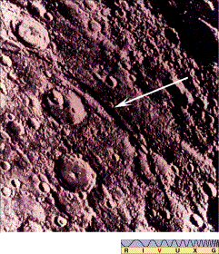
Figure 8.21 Discovery Scarp on Mercury's surface. This appears to be a compressional feature that formed when the planet's crust cooled and contracted early in its history, causing a crease in the surface. This scarp, running diagonally across the center of the frame, is several hundred kilometers long and up to 3 km high in places. (Another scarp can be seen in the top left of the figure, close to the horizon.)
Figure 8.22 shows what may have been the last great geological event in the history of Mercury—an immense bull's-eye crater called the Caloris Basin, formed eons ago by the impact of a large asteroid. (The basin is so called because it lies in Mercury's "hot longitudes"—see Section 8.3—close to the planet's equator; calor is the Latin word for "heat.") Because of the orientation of the planet during Mariner 10's flybys, only half of the basin was visible. The center of the crater is off the left-hand side of the photograph. Compare this basin with the Orientale Basin on the Moon (Figure 8.15a). The impact-crater structures are quite similar, but even here there is a mystery: the patterns visible on the Caloris floor are unlike any seen on the Moon. Their origin, like the composition of the floor itself, is unknown.
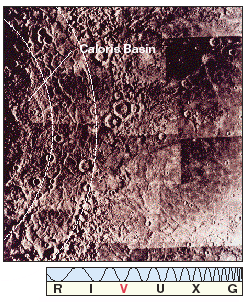
Figure 8.22 Mercury's most prominent geological feature—the Caloris Basin—measures about 1400 km across and is ringed by concentric mountain ranges that reach more than 3 km high in places. This huge circular basin, only half of which can be seen (at the left) in this Mariner 10 photo, is similar in size to the Moon's Mare Imbrium and spans more than half of Mercury's radius.
So large was the impact that created the Caloris basin that it apparently sent strong seismic waves reverberating throughout the entire planet. On the opposite side of Mercury from Caloris there is a region of oddly rippled and wavy surface features, often usually referred to as weird (or jumbled) terrain. Scientists believe that this terrain was produced when seismic waves from the Caloris impact traveled around the planet and converged on the diametrically opposite point, causing large-scale disruption of the surface there, as illustrated in Figure 8.23.

Figure 8.23 The refocusing of seismic waves after the Caloris Basin impact may have created the weird terrain on the opposite side of the planet.