| The Clementine satellite was sent to the Moon in 1994 by the U.S. Defense Department, largely to test some new sensing devices developed for the ballistic missile defense program. This was the first lunar mission by any nation since the crew of Apollo 17 left the Moon in 1972. Now, some of the data from this mission have been made public, and the results are remarkable—not only for the high quality of the science returned but also because Clementine was a miniature satellite that cost just $70 million, a small fraction of the cost of most other planetary spacecraft, which normally carry price tags of hundreds of millions, sometimes even billions, of dollars.
Clementine originally was a code word for a military-classified space project known as the Deep Space Program Science Experiment. The vehicle and its onboard suite of instruments were designed to test the feasibility of miniaturizing a complex spacecraft, its engineering subsystems, and its sophisticated sensors for use in deep space. The spacecraft's total mass was less than 150 kg. Clementine's technical design was a product of the Strategic Defense Initiative—the Star Wars program—now known as the Ballistic Missile Defense Organization. Its target—the Moon—was of no interest to the military, other than being a convenient, known subject in the cosmic neighborhood. The lunar mission was a spectacular success, although a follow-on mission to map an asteroid was canceled. Clementine was able to make the first digital global map of the Moon, and it did so with very high resolution. In 2 months of operation, its sensors took over 2.5 million images with a clarity at least 10 times better than NASA's most sophisticated planetary camera in the 1990s—the one onboard the Galileo mission to Jupiter—and Clementine's highest-resolution camera imaged the Moon with up to 100 times better resolution than |
Galileo can achieve. Clementine was able to obtain global coverage of the Moon at visible, ultraviolet, and infrared wavelengths, and to sense the Moon in 11 different spectral bands. In addition, the small craft also carried lidar devices (the visible equivalent of radar), able to pulse the lunar surface and listen for echoes. In all, more than 50 advanced lightweight technologies were demonstrated on this powerful dwarf spacecraft. Maybe "smaller, faster, cheaper" really is better.
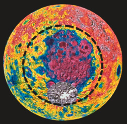
The first figure shows a mosaic of about 1500 images centered on the Moon's south pole. The bottom half is part of the near side of the Moon, as seen from Earth; the top half is the far side that we never see from home. For scale, the double-ringed crater at upper left, called Schroedinger, has an outer diameter of 320 km. The dark region at the pole is an old, permanently shadowed depression. Radar echoes captured by Clementine from within it suggested deposits of water ice at a depth of a few meters. As reported in Interlude 8-1, these findings have since been confirmed by NASA's Lunar Prospector mission. The second illustration is not an image; it is an altimetry map—that is, an elevation map of the mountains and valleys—for nearly the same south polar region. The colors indicate the ups and downs in the terrain—a good example of how the Clementine orbiter found that the Moon is a good deal rougher than was previously thought. The big, dark feature at center is named Aitken Basin. Its rim (yellow, outlined with black dashed circle) spans some 2000 km; the basin itself (mostly purple) averages 10 km deep. This huge depression is the largest impact basin known in the solar system. The violent collision that created this gargantuan scar must have thrown quadrillions of tons of lunar debris far into space, some of which, perhaps, eventually landed on Earth. |
 |
 |