 MORE PRECISELY 1-2 Celestial Coordinates MORE PRECISELY 1-2 Celestial Coordinates |
|
|---|---|
The simplest method of locating stars in the sky is to specify their constellation and then rank the stars in it in order of brightness. The brightest star is denoted by the Greek letter  (alpha), the second brightest by (alpha), the second brightest by  (beta), and so on. Thus, the two brightest stars in the constellation Orion—Betelgeuse and Rigel—are also known as Orionis and Orionis, respectively. (Precise recent observations show that Rigel is actually brighter than Betelgeuse, but the names are now permanent.) Because there are many more stars in any given constellation than there are letters in the Greek alphabet, this method is of limited utility. However, for naked-eye astronomy, where only bright stars are involved, it is quite satisfactory. (beta), and so on. Thus, the two brightest stars in the constellation Orion—Betelgeuse and Rigel—are also known as Orionis and Orionis, respectively. (Precise recent observations show that Rigel is actually brighter than Betelgeuse, but the names are now permanent.) Because there are many more stars in any given constellation than there are letters in the Greek alphabet, this method is of limited utility. However, for naked-eye astronomy, where only bright stars are involved, it is quite satisfactory.
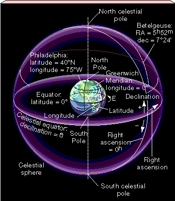
For more precise measurements, astronomers find it helpful to lay down a system of celestial coordinates on the sky. If we think of the stars as being attached to the celestial sphere centered on Earth, then the familiar system of latitude and longitude on Earth's surface extends naturally to cover the sky. The celestial analogs of latitude and longitude on Earth's surface are called declination and right ascension, respectively. The accompanying figure illustrates the meanings of right ascension and declination on the celestial sphere and compares them with longitude and latitude on Earth. Declination (dec) is measured in degrees (°) north or south of the celestial equator, just as latitude is measured in degrees north or south of Earth's equator. (See More Precisely 1-1 for a discussion of angular measure.) Thus, the celestial equator is at a declination of 0°, the north celestial pole is at +90°, and the south celestial pole is at -90° (the minus sign here just means "south of the celestial equator"). Right ascension (RA) is measured in units called hours, minutes, and seconds, and it increases in the eastward direction. The angular units used to measure right ascension are constructed to parallel the units of time; the two sets of units are connected by the rotation of Earth (or of the celestial sphere). In 24 hours, Earth rotates once on its axis, or through 360°. Thus, in a time period of 1 hour, Earth rotates through 360°/24 |
Just as longitude and latitude allow us to locate a point on Earth's surface, right ascension and declination specify locations on the sky. For example, to find Philadelphia on Earth, look 75° west of the Greenwich Meridian and 40° north of the equator (as marked on the figure). Similarly, to locate the star Betelgeuse on the celestial sphere, look 5h52m east of the vernal equinox (the line on the sky with a right ascension of zero) and 7° 249 north of the celestial equator.
The units of right ascension were originally defined to assist astronomical observation, but the names are rather unfortunate, as these are angular measures, not units of time. Moreover, the angular units used for right ascension are not the same units as defined in More Precisely 1-1. In fact, right ascension 1m =15°/60 = 0.25°, or 15 arc minutes (15'). Similarly, right ascension 1s = 15 arc seconds (15"). If you remember that the units of right ascension are used only for that one purpose, and that all angular measurements except right ascension use arc minutes (') and arc seconds ("), you should avoid undue confusion. Just as latitude and longitude are tied to Earth, right ascension and declination are fixed on the celestial sphere. Although the stars appear to move across the sky because of Earth's rotation, their celestial coordinates remain constant over the course of a night. Thus, we have a quantitative alternative to the use of constellations in specifying the positions of stars in the sky. For example, the stars Rigel and Betelgeuse mentioned earlier can be precisely located by looking in the directions 5h13m36s (RA), -8° 13' (dec) and 5h52m0s (RA), 07° 24' (dec), respectively. The coordinates of Betelgeuse on the celestial sphere are marked on the figure. Actually, because right ascension is tied to the position of the vernal equinox, the celestial coordinates of any given star drift slowly due to Earth's precession (see Section 1.4). Since one cycle of precession takes some 26,000 years to complete, this represents a shift of a little over 0.1" on a night-to-night basis—a small angle, but one that nevertheless must be taken into account in high-precision astronomical measurements. Rather than deal with slowly changing coordinates for every object in the sky, astronomers conventionally correct their observations to the location of the vernal equinox at some standard epoch (for example, January 1, 1950, or January 1, 2000). |
 |
|