Although its clouds are thick and the terrain below them totally shrouded, we are by no means ignorant of Venus's surface. Radar astronomers have bombarded the planet with radio signals, both from Earth and from the Venera, Pioneer Venus, and, most recently, the Magellan spacecraft.
  (Sec. 6.6) Analysis of the radar echoes yields a map of the planet's surface; except for the last two figures, all the views of Venus in this section are "radargraphs" (not photographs) created in this way. As Figure 9.7(a) illustrates, the early maps of Venus suffered from poor resolution; however, more recent probes, especially Magellan, have provided much sharper views. As in all the Magellan images, the light areas in Figure 9.7(b) represent regions where the surface is rough and efficiently scatters Magellan's sideways-looking radar beam back to the detector. Smooth areas tend to reflect the beam off into space instead and so appear dark.
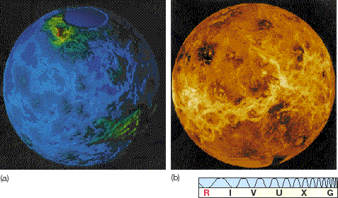
Figure 9.7 (a) This image of the surface of Venus was made by a radar transmitter and receiver onboard the Pioneer spacecraft, which is still in orbit about the planet but is now inoperative. The two continent-sized landmasses are named Ishtar Terra (upper left) and Aphrodite (lower right). Colors represent altitude: blue is lowest, red highest. The spatial resolution is about 25 km. (b) A planetwide mosaic of Magellan images. The largest "continent" on Venus, Aphrodite Terra, is at the center of the image.
Figure 9.8(a) shows basically the same Pioneer Venus data of Venus as Figure 9.7(a), except that it has been flattened out into a more conventional map. The altitude of the surface relative to the average radius of the planet is indicated by the use of color, with white representing the highest elevations, blue the lowest. (Note that the blue has nothing to do with oceans, and white does not indicate snow-capped mountains!) A few of the planet's main features are labeled in Figure 9.8(c). Figure 9.8(b) shows a map of Earth to the same scale and at the same spatial resolution.
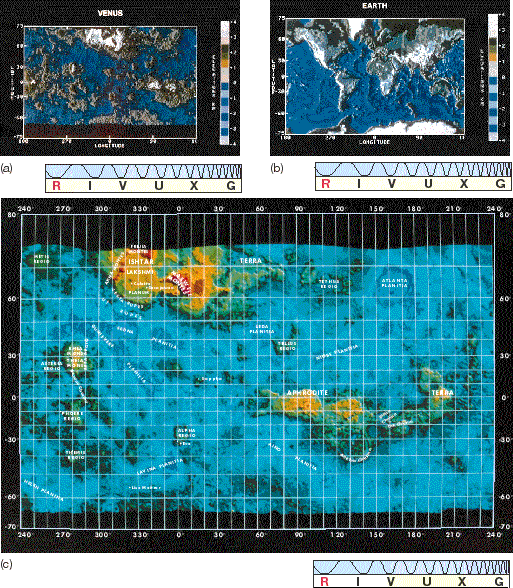
Figure 9.8 (a) Radar map of the surface of Venus, based on the Pioneer Venus data. Color represents elevation according to the scale at the right. (b) A similar map of Earth, at the same spatial resolution. (c) Another version of (a), with major surface features labeled.
The surface of Venus appears to be relatively smooth, resembling rolling plains with modest highlands and lowlands. Two continent-sized features, called Ishtar Terra and Aphrodite Terra (named after the Babylonian and Greek counterparts, respectively, of Venus, the Roman goddess of love), adorn the landscape, and these contain mountains comparable in height to those on Earth. The elevated "continents" occupy only 8 percent of Venus's total surface area. For comparison, continents on Earth make up about 25 percent of the surface. The remainder of Venus's surface is classified as lowlands (27 percent) or rolling plains (65 percent), although there is probably little geological difference between the two terrains. Note that, while Earth's tectonic plate boundaries are plainly evident in Figure 9.8(b), no similar features can be seen in Figure 9.8(a). (Sec. 7.5) There appears to be no large-scale plate tectonics on Venus.
Ishtar Terra ("Land of Ishtar") lies in the southern high latitudes (at the top of Figure 9.8a—recall our earlier discussion of Venus's retrograde rotation). The projection of the map makes Ishtar Terra appear much larger than it really is—it is actually about the same size as Australia. This landmass is dominated by a great plateau known as Lakshmi Planum (Figure 9.9), which is some 1500 km across at its widest point. This plain is ringed by mountain ranges that include the highest peak on the planet, Maxwell Mons, which rises some 14 km above the level of Venus's deepest surface depressions. Again for comparison, the highest point on Earth (the summit of Mount Everest) lies about 20 km above the deepest section of Earth's ocean floor (Challenger Deep, at the bottom of the Marianas Trench on the eastern edge of the Philippines plate).
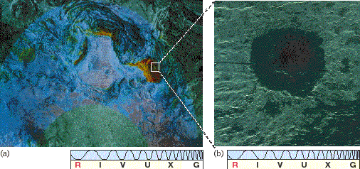
Figure 9.9 (a) A Venera orbiter image of a plateau in Ishtar Terra known as Lakshmi Planum. Maxwell Mons (red) lies on the western margin of the plain, near the right-hand edge of the image. A meteor crater named Cleopatra is visible on the western slope of the Maxwell mountain range. Note the two larger craters in the center of the plain itself. (b) A Magellan image of Cleopatra showing a double-ringed structure that identifies it to geologists as an impact crater.
Figure 9.9(a) shows a large-scale Venera image of Lakshmi Planum, at a resolution of about 2 km. The "wrinkles" are actually chains of mountains, hundreds of kilometers long and tens of kilometers apart. The red area immediately to the right of the plain is Maxwell Mons. On the western (right-hand) slope of the Maxwell range lies a great crater, called Cleopatra, about 100 km across. Figure 9.9(b) shows a Magellan image of Cleopatra. Close-up views of the crater's structure have led planetary scientists to conclude that it is meteoritic in origin, although some volcanic activity was associated with its formation. Notice the dark (smooth) lava flow emerging from within the inner ring and cutting across the outer rim at the upper right.
It is now conventional to name features on Venus after famous women—Aphrodite, Ishtar, Cleopatra, and so on. However, the early nonfemale names (for example, Maxwell Mons, named after the Scottish physicist James Clerk Maxwell) predating this convention have stuck, and they are unlikely to change.
Venus's other continent-sized formation, Aphrodite Terra, is located on the planet's equator and is comparable in size to Africa. Before Magellan's arrival, some researchers had speculated that Aphrodite Terra might have been the site of something akin to seafloor spreading on Earth—a region where two lithospheric plates moved apart and molten rock rose to the surface in the gap between them, forming an extended ridge. With the low-resolution data then available, the issue could not be settled at the time.
The Magellan images now seem to rule out even this small-scale tectonic activity, and the Aphrodite region shows no signs of spreading. Figure 9.10(a) shows a portion of Aphrodite Terra called Ovda Regio. The crust appears buckled and fractured, with ridges running in two distinct directions across the image, suggesting that large compressive forces are distorting the crust. There seem to have been repeated periods when extensive lava flows occurred. The dark regions are probably solidified lava flows. Some narrow lava channels, akin to rilles on the Moon, also appear. Figure 9.10(b) shows a series of angular cracks in the crust, thought to have formed when lava welled up from a deep fissure, flooded the surrounding area, and then retreated back below the planet's surface. As the molten lava withdrew, the thin new crust of solidified material collapsed under its own weight, forming the cracks we now see. Even taking into account the temperature and composition differences between Venus's crust and Earth's, this terrain is not at all what we would expect at a spreading site similar to the Mid-Atlantic Ridge. (Sec. 7.5)

Figure 9.10 (a) A Magellan image of Ovda Regio, part of Aphrodite Terra. The intersecting ridges indicate repeated compression and buckling of the surface. The dark areas represent regions that have been flooded by lava upwelling from cracks like those shown in (b), detected by Magellan in another part of Aphrodite Terra. This network of fissures is about 50 km long.
Although there is no evidence for plate tectonics on Venus, it is likely that the stresses in the crust that led to the large mountain ranges were caused by convective motion within Venus's mantle, the same basic process that drives Earth's plates. (Sec. 7.5) Lakshmi Planum, for example, is probably the result of a "plume" of upwelling mantle material that raised and buckled the planet's surface.
Many areas of Venus have extensive volcanic features. Figure 9.11 shows a series of seven pancake-shaped lava domes, each about 25 km across. They probably formed when lava oozed out of the surface, formed the dome, and then withdrew, leaving the crust to crack and subside. Lava domes such as these are found in numerous locations on Venus. The most common volcanoes on the planet are of the type known as shield volcanoes. Two large shield volcanoes, called Sif Mons and Gula Mons, are shown (in false color) in Figure 9.12. Shield volcanoes, such as the Hawaiian Islands on Earth, are not associated with plate boundaries. Instead, they form when lava wells up through a "hot spot" in the crust, and are built up over long periods of time by successive eruptions and lava flows. A characteristic of shield volcanoes is the formation of a caldera, or crater, at the summit when the underlying lava withdraws and the surface collapses.
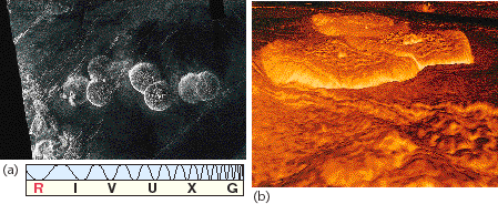
Figure 9.11 (a) These dome-shaped structures resulted when viscous molten rock bulged out of the ground and then retreated, leaving behind a thin solid crust that subsequently cracked and subsided. Magellan has found features like this in several locations on Venus. (b) A three-dimensional representation of four of the domes. The computer view is looking toward the right from near the center of the image in part (a). Color is based on data returned by Soviet Venera landers.

Figure 9.12 (a) Two larger volcanoes, known as Sif Mons (left) and Gula Mons, appear in this Magellan image. Color indicates height, ranging from purple (the level of the surrounding plain) to orange (corresponding to an altitude of about 4 km). The two volcanic calderas at the summits are about 100 km across. (b) A computer-generated view of Sif Mons, as seen from ground level. (c) Gula Mons, as seen from ground level. In (b) and (c), the colors are based on data returned from Soviet landers, and the vertical scales have been greatly exaggerated; Venus is actually a remarkably flat place.
The largest volcanic structures on Venus are huge, roughly circular regions known as coronae. A large corona, called Aine, can be seen in Figure 9.13, another large-scale mosaic of Magellan images. Coronae are unique to Venus. They appear to have been caused by upwelling mantle material, similar to the uplift that resulted in Lakshmi Planum, but on a somewhat smaller scale. They generally have volcanoes both in and around them, and closer inspection of the rims usually shows evidence for extensive lava flows into the plains below.
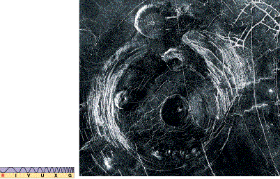
Figure 9.13 This corona, called Aine, lies in the plains south of Aphrodite Terra; it is about 300 km across. It is probably the result of mantle material that upwelled, causing the surface to bulge outward. Note the fractures in the crust, and the many large impact craters with their surrounding white (rough) ejecta blankets that stud the region.
There is overwhelming evidence for past surface activity on Venus. Has this activity now stopped, or is it still going on? Two pieces of indirect evidence suggest that volcanism continues today. First, the level of sulfur dioxide above Venus's clouds shows large and fairly frequent fluctuations. It is quite possible that these variations result from volcanic eruptions on the surface. If so, volcanism may be the primary cause of Venus's thick cloud cover. Second, both the Pioneer Venus and the Venera orbiters observed bursts of radio energy from Aphrodite and other regions of the planet's surface. These bursts are similar to those produced by lightning discharges that often occur in the plumes of erupting volcanoes on Earth, again suggesting ongoing activity. However, while these pieces of evidence are quite persuasive, they are still only circumstantial. No "smoking gun" (or erupting volcano) has yet been seen, so the case for active volcanism is not yet complete.
Not all the craters on Venus are volcanic in origin. Some, like Cleopatra (Figure 9.9b), were formed by meteoritic impact. Large impact craters on Venus are generally circular, but those less than about 15 km in diameter can be quite asymmetric in appearance. Figure 9.14(a) shows a Magellan image of a relatively small meteoritic impact crater, about 10 km across, in Venus's southern hemisphere. Geologists believe the light-colored region to be the ejecta blanket—material ejected from the crater following the impact. The odd shape may be the result of a large meteoroid's breaking up just before impact into pieces that hit the surface near one another. This seems to be a fairly common fate for medium-sized bodies (1 km or so in diameter) that plow through Venus's dense atmosphere. Numerous impact craters, again identifiable by their ejecta blankets, can also be discerned in Figure 9.13.
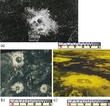
Figure 9.14 (a) A Magellan image of an impact crater in Venus's southern hemisphere. The peculiar kidney shape seems to be the result of a meteoroid that fragmented just prior to impact. The dark regions in the crater may be pools of solidified lava. (b) Some more regular looking craters. (c) Three-dimensional computer-generated representations of the craters shown in part (b).
Venus's atmosphere is sufficiently thick that small meteoroids do not reach the ground, so there are no impact craters smaller than about 3 km across. Atmospheric effects probably also account for the observed scarcity of impact craters less than 25 km in diameter. Overall, the rate of formation of large-diameter craters on Venus's surface seems to be only about 1/10 that in the lunar maria. Applying the same crater-age estimates to Venus as we do to Earth and the Moon suggests that much of the surface of Venus is quite young—around a billion years old. Some planetary scientists have suggested that some areas, such as the region shown in Figure 9.12 are even younger—perhaps as little as 200 or 300 million years old. Although erosion by the planet's atmosphere may play some part in obliterating surface features, the main agent is volcanism, which appears to "resurface" the planet every few hundred million years.
The 1975 soft landings of the Soviet Venera 9 and Venera 10 spacecraft established directly that Venus's surface is very dry and dusty. Figure 9.15 shows one of the first photographs of the surface of Venus radioed back to Earth. Each craft lasted only about an hour before overheating, their electronic circuitry literally melting in this planetary oven. Typical rocks in the photo measure about 50 cm by 20 cm across—a little like flagstones on Earth. Having sharp edges and a slablike character, they show little evidence of erosion. Apparently they are quite young rocks, again supporting the idea of ongoing surface activity of some kind.

Figure 9.15 The first direct view of the surface of Venus, radioed back to Earth from the Soviet Venera 9 spacecraft, which made a soft landing on the planet in 1975. The amount of sunlight penetrating Venus's cloud cover apparently resembles that on a heavily overcast day on Earth.
Later Venera missions took more detailed photographs, as shown in Figure 9.16. The presence of small rocks and finer material indicates the effects of erosive processes. These later missions also performed simple chemical analyses of the surface of Venus. The samples studied by Venera 13 and Venera 14 were predominantly basaltic in nature, again implying a volcanic past. However, not all the rocks were found to be volcanic. The Venera 17 and Venera 18 landers also found surface material resembling terrestrial granite, probably (as on Earth) part of the planet's ancient crust.
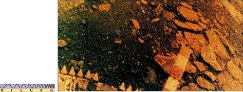
Figure 9.16 Another view of Venus, in true color, from Venera 14. Flat rocks like those visible in Figure 9.15 are present, but there are also many smaller rocks and even fine soil on the surface. This landing site is not far from the Venera 9 site shown in the previous figure. The peculiar filtering effects of whatever light does penetrate the clouds make Venus's air and ground peach-colored.