Maps of the surface of Mars returned by orbiting spacecraft show a wide range of geological features. Mars has huge volcanoes, deep canyons, vast dune fields, and many other geological wonders. Orbiters have performed large-scale surveys of much of the planet's surface; lander data have complemented these planetwide studies with detailed information on (so far) three specific sites.
  (Sec. 6.6)
A striking feature of the terrain of Mars is the marked difference between the northern and southern hemispheres. The northern hemisphere is made up largely of rolling volcanic plains, not unlike the lunar maria. These extensive lava plains—much larger than those found on Earth or the Moon—were formed by eruptions involving enormous volumes of lava. They are strewn with blocks of volcanic rock as well as with boulders blasted out of impact areas by infalling meteoroids (the Martian atmosphere is too thin to offer much resistance to incoming debris). The southern hemisphere consists of heavily cratered highlands lying several kilometers above the level of the lowland north. Most of the dark regions visible from Earth are mountainous regions in the south. Figure 10.3 contrasts typical terrains in the two hemispheres.
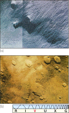
Figure 10.3 (a) The northern hemisphere of Mars consists of rolling, volcanic plains. (b) The southern Martian highlands are heavily cratered (true color).
The northern plains are much less cratered than the southern highlands. On the basis of arguments presented in Chapter 8, this smoother surface suggests that the northern surface is younger. (Sec. 8.4) Its age is perhaps 3 billion years, compared with 4 billion in the south. In places, the boundary between the southern highlands and the northern plains is quite sharp. The surface level can drop by as much as 4 km in a distance of 100 km or so. Most scientists assume that the southern terrain is the original crust of the planet. How most of the northern hemisphere could have been lowered in elevation and flooded with lava remains a mystery.
The major geological feature on the planet is the Tharsis bulge (visible in Figure 10.4, a Viking mosaic of Mars). Roughly the size of North America, Tharsis lies on the Martian equator, and rises some 10 km higher than the rest of the Martian surface. To its east lies Chryse Planitia (the "Plains of Gold"); to the west a region called Isidis Planitia (the "Plains of Isis," an Egyptian goddess). These features are wide depressions, hundreds of kilometers across and up to 3 km deep. If we wished to extend the idea of "continents" from Earth and Venus to Mars, we would conclude that Tharsis is the only continent on the Martian surface. However, as on Venus, there is no sign of plate tectonics—the continent of Tharsis is not drifting like its Earthly counterparts. (Sec. 7.5)
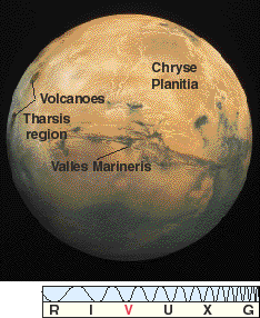
Figure 10.4 The Tharsis region of Mars, some 5000 km across, bulges out from the planet's equatorial region, rising to a height of about 10 km. The large volcanoes on the left mark the approximate peak of the bulge. One of the plains flanking the Tharsis bulge, Chryse Planitia, is toward the right. Dominating the center of the field of view is a vast "canyon" known as Valles Marineris. (See also the chapter-opening image)
Tharsis appears to be even less heavily cratered than the northern plains, making it the youngest region on the planet. It is estimated to be only 2 to 3 billion years old.
Mars contains the largest known volcanoes in the solar system. Four very large volcanoes are found on the Tharsis bulge, two of them visible on the left hand side of Figure 10.4. The largest volcano of all is Olympus Mons (Figure 10.5), on the northwestern slope of Tharsis, lying just over the (western) horizon of Figure 10.4. It measures some 700 km in diameter at its base—only slightly smaller than the state of Texas—and rises to a height of 25 km above the surrounding plains. The caldera, or crater, at its summit, measures 80 km across. The other three large volcanoes are a little smaller—a mere 18 km high—and lie near the top of the bulge.
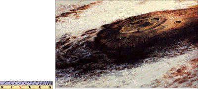
Figure 10.5 Olympus Mons, the largest volcano known on Mars or anywhere else in the solar system. Nearly three times taller than Mount Everest on Earth, this Martian mountain measures about 700 km across the base and extends 25 km at the peak. It seems currently inactive and may have been extinct for at least several hundred million years. By comparison, the largest volcano on Earth, Hawaii's Mauna Loa, measures a mere 120 km across and peaks just 9 km above the Pacific Ocean floor.
Like Maxwell Mons on Venus, these volcanoes are not associated with plate motion but instead are shield volcanoes (see Section 9.4), sitting atop a hot spot in the underlying Martian mantle. All four show distinctive lava channels and other flow features very similar to those found on shield volcanoes on Earth. The Viking images of the Martian surface reveal many hundreds of volcanoes. Most of the largest are associated with the Tharsis bulge, but many smaller volcanoes are also found in the northern plains.
The great height of Martian volcanoes is a direct consequence of the planet's low surface gravity. As lava flows and spreads to form a shield volcano, its eventual height depends on the new mountain's ability to support its own weight. The lower the gravity, the less the weight and the higher the mountain. It is no accident that Maxwell Mons on Venus and the Hawaiian shield volcanoes on Earth rise to roughly the same height (about 10 km) above their respective bases—Earth and Venus have similar surface gravity. Mars's surface gravity is only 40 percent that of Earth, so volcanoes rise roughly 2.5 times as high.
Are these volcanoes still active? Scientists have found no direct evidence for recent or ongoing eruptions. However, if these volcanoes were around since the Tharsis uplift (as the formation of the Tharsis bulge is known) and were active as recently as 100 million years ago (an age estimate based on the extent of impact cratering on their slopes), some of them may still be at least intermittently active. Millions of years, though, may pass between eruptions.
The Mariner spacecraft found that the surfaces of Mars and its two moons are pitted with impact craters formed by meteoroids falling in from space. As on our Moon, the smaller craters are often filled with surface matter—mostly dust—confirming that Mars is a dry, desert world. However, Martian craters are filled in considerably faster than their lunar counterparts. On the Moon, ancient craters less than 20 m deep (corresponding to a diameter of about 100 m) have been obliterated, primarily by meteoritic erosion. (Sec. 8.4) On Mars, there is also a lack of small craters, but extending to craters 5 km in diameter. The Martian atmosphere is an efficient erosive agent, transporting dust from place to place and erasing surface features much faster than meteoritic impacts alone can obliterate them.
As on the Moon, the extent of large impact cratering (that is, craters too big to have been filled in by erosion since they formed) serves as an age indicator for the Martian surface. The ages quoted earlier, ranging from 4 billion years for the southern highlands to a few hundred million years in the youngest volcanic areas, were obtained in this way.
The detailed appearance of Martian impact craters provides an important piece of information about conditions just below the planet's surface. However the ejecta blankets surrounding many Martian craters look quite different from their lunar counterparts. Figure 10.6 compares the Copernicus crater on the Moon with the (fairly typical) crater Yuty on Mars. The material surrounding the lunar crater is just what one would expect from an explosion ejecting a large volume of dust, soil, and boulders. However, the ejecta blanket on Mars gives the distinct impression of a liquid that has splashed or flowed out of the crater. Geologists believe that this fluidized ejecta crater indicates that a layer of permafrost, or water ice, lies just under the surface. The explosive impact heated and liquefied the ice, resulting in the fluid appearance of the ejecta.
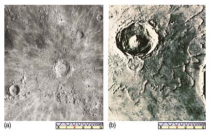
Figure 10.6 (a) The large lunar crater Copernicus is quite typical of those found on Earth's Moon. Its ejecta blanket appears to be composed of dry, powdery material. (b) The ejecta from Mars's crater Yuty (18 km in diameter) evidently was liquid in nature. This type of crater is sometimes called a "splosh" crater.
Yet another feature associated with the Tharsis bulge is a great "canyon" known as Valles Marineris (the Mariner Valley). Shown in its entirety in Figure 10.4 and in more detail in Figure 10.7, it is not really a canyon in the terrestrial sense, because running water played no part in its formation. Planetary astronomers believe that it was formed by the same crustal forces that forced the entire Tharsis region to bulge outward, causing the surface to split and crack. These cracks, called tectonic fractures, are found all around the Tharsis bulge. The Valles Marineris is the largest of them. Cratering studies suggest that the cracks are at least 2 billion years old. Similar (but much smaller) cracks, with similar causes, have been found in the Aphrodite Terra region of Venus, as we saw in Chapter 9. (Sec. 9.4)
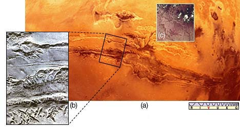
Figure 10.7 (a) The Mariner Valley is an incredibly huge canyon, 120 km wide and 7 km deep. Its length is about 4000 km, or nearly the full breadth of the continental United States. (b) A close-up view shows the complexity of the valley walls and dry tributaries. (c) A comparison, to scale, with Earth's Grand Canyon, which is a mere 20 km wide and 2 km deep, suggests just how big the Mariner Valley is.
Valles Marineris runs for almost 4000 km along the Martian equator, about one-fifth of the way around the planet. At its widest, it is some 120 km across, and it is as deep as 7 km in places. Like many Martian surface features, it simply dwarfs Earthly competition. The Grand Canyon in Arizona would easily fit into one of its side "tributary" cracks. Valles Marineris is so large that it can even be seen from Earth—in fact, it was one of the few "canals" observed by nineteenth-century astronomers (see Interlude 10-1) that actually corresponded to a real feature on the planet's surface (it was known as the Coprates canal). We must reemphasize, however, that this Martian feature was not constructed by intelligent beings, nor was it carved by a river, nor is it a result of Martian plate tectonics. For some reason, the crustal forces that formed it never developed into full-fledged plate motion as on Earth.
Although the great surface cracks in the Tharsis region are not really canyons and were not formed by running water, photographic evidence reveals that liquid water once existed in great quantity on the surface of Mars. Two types of flow feature are seen: the runoff channels and the outflow channels.
The runoff channels (one of which is shown in Figure 10.8) are found in the southern highlands. They are extensive systems—sometimes hundreds of kilometers in total length—of interconnecting, twisting channels that seem to merge into larger, wider channels. They bear a strong resemblance to river systems on Earth, and it is believed by geologists that this is just what they are—the dried-up beds of long-gone rivers that once carried rainfall on Mars from the mountains down into the valleys. These runoff channels speak of a time 4 billion years ago (the age of the Martian highlands), when the atmosphere was thicker, the surface warmer, and liquid water widespread.
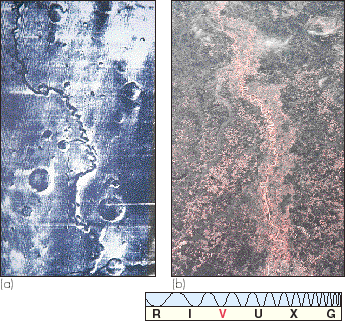
Figure 10.8 (a) This runoff channel on Mars measures about 400 km long and 5 km wide. Here, we compare it with a photograph of the Red River (b) running from Shreveport, Louisiana, to the Mississippi River. The two differ mainly in that there is currently no liquid water in this, or any other, Martian valley.
The outflow channels (Figure 10.9) are probably relics of catastrophic flooding on Mars long ago. They appear only in equatorial regions and generally do not form the extensive interconnected networks that characterize the runoff channels. Instead, they are probably the paths taken by huge volumes of water draining from the southern highlands into the northern plains. The onrushing water arising from these flash floods probably also formed the odd teardrop-shaped "islands" (resembling the miniature versions seen in the wet sand of our beaches at low tide) that have been found on the plains close to the ends of the outflow channels (Figure 10.10). Judging from the width and depth of the channels, the flow rates must have been truly enormous—perhaps as much as a hundred times greater than the 105 tons per second carried by the Amazon river, the largest river system on Earth. Flooding shaped the outflow channels about 3 billion years ago, about the same time as the northern volcanic plains formed.
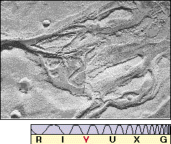
Figure 10.9 An outflow channel near the Martian equator bears witness to a catastrophic flood that occurred about 3 billion years ago.
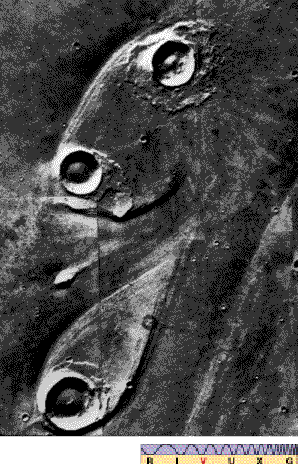
Figure 10.10 The onrushing water that carved out the outflow channels was responsible for forming these oddly shaped "islands" as the flow encountered obstacles—impact craters—in its path. Each "island" is about 40 km long.
Planetary astronomers find no evidence for liquid water anywhere on Mars today, and the amount of water vapor in the Martian atmosphere is tiny. Yet the extent of the outflow channels indicates that a huge total volume of water existed on Mars in the past. Where did all that water come from? And where did it all go? The answer may be that virtually all the water on Mars is now locked in the permafrost layer under the surface, with perhaps a little more contained in the polar caps. Four billion years ago, as climatic conditions changed, the running water that formed the runoff channels began to freeze, forming the permafrost and drying out the river beds. Mars remained frozen for about a billion years, until volcanic (or some other) activity heated large regions of the surface, melting the subsurface ice and causing the flash floods that created the outflow channels. Subsequently, volcanic activity subsided, the water refroze, and Mars once again became a dry world.
We have already noted that Mars's polar caps are composed predominantly of carbon dioxide frost—dry ice—and show seasonal variations. Each cap in fact consists of two distinct parts—the seasonal cap, which grows and shrinks each Martian year, and the residual cap, which remains permanently frozen. At maximum size, in southern midwinter, the southern seasonal cap is some 4000 km across. Half a Martian year later, the northern cap is at its largest, reaching a diameter of roughly 3000 km. The two seasonal polar caps do not have the same maximum size because of the eccentricity of Mars's orbit around the Sun. During southern winter, Mars is considerably farther from the Sun than half a year later, in northern winter. The southern winter season is longer and colder than that of the north, and the polar cap grows correspondingly larger.
The seasonal caps are composed entirely of carbon dioxide. Their temperatures are never greater than about 150 K (—120° C), the point at which dry ice can form. During the Martian summer, when sunlight striking a cap is most intense, carbon dioxide evaporates into the atmosphere, and the cap shrinks. In the winter, atmospheric carbon dioxide refreezes, and the cap reforms. As the caps grow and shrink, they cause substantial variations (up to 30 percent) in the Martian atmospheric pressure—a large fraction of the planet's atmosphere freezes out and evaporates again on a yearly basis. From studies of these atmospheric fluctuations, scientists can estimate the amount of carbon dioxide in the seasonal polar caps. The maximum thickness of the seasonal caps is thought to be about 1 m.
The residual caps, shown in Figure 10.11, are smaller and brighter than the seasonal caps and show an even more marked north—south asymmetry. The southern residual cap is about 350 km across and, like the seasonal caps, is made mostly of carbon dioxide, although it may contain some water ice. Its temperature remains below 150 K at all times. The northern residual cap is much larger—about 1000 km across—and warmer, with a temperature that can exceed 200 K in northern summertime. Planetary scientists believe that the northern cap is made mostly of water ice, an opinion strengthened by the observed increase in the concentration of water vapor above the north pole in northern summer as some small fraction of its water ice evaporates in the Sun's heat. It is quite possible that the northern residual polar cap is a major storehouse for water on Mars.

Figure 10.11 The southern (a) and northern (b) polar caps of Mars are shown to scale in these mosaics of Mariner 9 images. These are the residual caps, seen here during their respective summers half a Martian year apart. The southern cap is only 350 km across and made up mostly of frozen carbon dioxide. The northern cap is about 1000 km across and composed mostly of water ice.
Why is there such a temperature difference (at least 50 K) between the two residual polar caps? The reason seems to be related to the giant dust storms that envelop the planet during southern summer. These storms, which last for a quarter of a Martian year (about 6 Earth months), tend to blow the dust from the warmer south into the cooler northern hemisphere. The northern ice cap becomes dusty and less reflective. As a result, it absorbs more sunlight and warms up.
Viking 11 landed in Chryse Planitia, the broad depression to the east of Tharsis. The view that greeted its cameras (Figure 10.12) was a windswept, gently rolling, rather desolate plain, littered with rocks of all sizes, not unlike a high desert on Earth. The surface rocks visible in Figure 10.12 are probably part of the ejecta blanket of a nearby impact crater. Viking 2 landed somewhat farther north, in a region of Mars called Utopia, chosen in part because mission planners anticipated greater seasonal climatic variations there. The plain on which Viking 2 landed was flat and featureless. From space, the landing site appeared smooth and dusty. In fact, the surface turned out to be very rocky, even rockier than the Chryse site, and without the dust layer the mission directors had expected (Figure 10.13). The views that the two landers recorded may turn out to be quite typical of the low-latitude northern plains.
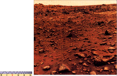
Figure 10.12 This is the view from the perspective of the Viking 1 spacecraft now parked on the surface of Mars. The fine-grained soil and the rock-strewn terrain stretching toward the horizon are reddish. Containing substantial amounts of iron ore, the surface of Mars is literally rusting away. The sky is a pale yellow-pink color, the result of airborne dust.
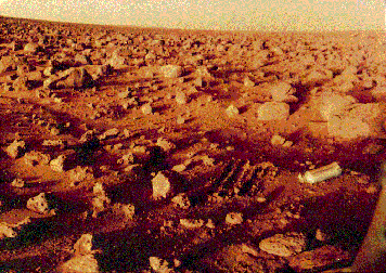
Figure 10.13 Another view of the Martian surface, this one rock-strewn and flat, as seen through the camera aboard the Viking 2 robot that soft-landed on the northern Utopian plains. The discarded canister is about 20 cm long. The 0.5=M scars in the "dirt" were made by the robot's shovel.
The Viking landers performed numerous chemical analyses of the Martian regolith. One important finding of these studies was the high iron content of the planet's surface. Chemical reactions between the iron-rich surface soil and free oxygen in the atmosphere is responsible for the iron oxide ("rust") that gives Mars its characteristic color. Although the surface layers are rich in iron relative to Earth's surface, the overall abundance is similar to Earth's average iron content. On Earth, much of the iron has differentiated to the center. Chemical differentiation does not appear to have been nearly so complete on Mars.
The most recent visitor to the Martian surface was Mars Pathfinder, along with its robot rover Sojourner. (Sec. 6.6[3]) During the unexpectedly long lifetime of its mission (which lasted almost 3 months instead of the anticipated 1), the lander performed measurements of the Martian atmosphere and atmospheric dust while Sojourner carried out chemical analyses of the soil and rocks within about 50 m of the parent craft. In addition, over 16,000 images of the region were returned to Earth.
The Pathfinder landing site (Figure 10.14) had been carefully chosen to lie near the mouth of an outflow channel, and the size distribution and composition of the many rocks and boulders surrounding the lander were consistent with their having been deposited there by floodwaters. In addition, the presence of numerous rounded pebbles strongly suggested the erosive action of running water at some time in the past. The soil chemistry in the vicinity of the landing site was similar to that found by the two Viking landers. Analyses of the nearby rocks revealed a chemical makeup different from that of the Martian meteorites found on Earth (see Interlude 10-2).
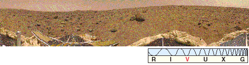
Figure 10.14 This 360° panorama of Mars was taken by the Pathfinder robot lander in 1997. Its small roving vehicle, Sojourner, can be seen up against a rock at center (see also Fig. 6.4). The "Twin Peaks" on the left-center horizon are 1—2 km away.